Rising Wildfire Threat Prompts Development of AI Solutions
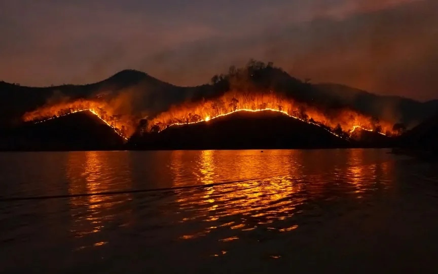
Artificial intelligence has emerged as a potential solution in the face of devastating wildfires caused by climate change. These fires have wreaked havoc on various communities, claiming numerous lives, depleting firefighters’ resources, and intensifying the need for innovative approaches.
Firefighters and startups use AI-powered cameras to search the horizon for signs of smoke. A German company is building a constellation of satellites to detect fires from space. And Microsoft uses artificial intelligence models to predict where the next fire might start.
As wildfires increase and become more intense as the world warms, firefighters, utilities and governments are scrambling to get ahead of the flames by leveraging the latest artificial intelligence technology – which has sparked both fear and excitement about its life-changing potential. While increasingly stretched first responders hope AI will give them a leg up, humans are still needed to check that the technology is accurate.
California’s main fire agency this summer began testing an artificial intelligence system that looks for smoke from the feeds of more than 1,000 mountaintop cameras, and is now expanding it statewide.
The system is designed to look for “anomalies” and alert emergency services, where staff will confirm whether it is indeed smoke or something else in the air.
“The beauty of this is that it immediately pops up on the screen and those dispatchers or the receivers of the call can examine that screen” and decide whether to send a crew, said Phillip SeLegue, chief of intelligence for the California Department of Forestry. Fire prevention.
The cameras, which are part of a network that workers previously had to monitor, provide billions of bytes of data for the AI system to digest. While people still need to confirm smoke sightings, the system helps reduce fatigue for workers who typically monitor multiple monitors and cameras, alerting them to look only when fire or smoke is possible, SeLegue said.
It has already helped. The battalion chief received a smoke alarm in the middle of the night, confirmed it on his cellphone and called the San Diego command center to alert first responders to the remote area.
Dispatchers said if they hadn’t been alerted, the fire would have been much bigger because it probably wouldn’t have been noticed until the next morning, SeLegue said.
San Francisco startup Pano AI is taking a similar approach, installing cameras on cell towers that look for smoke and alert customers, including fire departments, utility companies and ski resorts.
The cameras use computer vision machine learning, a type of artificial intelligence.
“They are specifically trained to detect smoke or not, and we train them with pictures of smoke and pictures of not smoking,” CEO Sonia Kastner said.
The images are combined with the administration’s Weather Satellite feed, which looks for the hotspot, as well as other sources of information, such as social media messages.
The technology circumvents one of the main problems with traditional wildfire detection – relying on 911 calls from passers-by, which need personnel confirmation before crews and water-dropping aircraft can be deployed.
“Typically, only one in 20 of those 911 calls is actually a wildfire. Even during a fire, it could be cloud, fog or barbecue,” Kastner said.
Pano AI systems still rely on final confirmation, and managers play a time delay from the camera feed to make sure that smoke goes up.
In fighting wildfires, “technology is becoming really essential,” said Larry Bekkedahl, director of energy supply at Portland General Electric, Oregon’s largest utility and Pano’s AI customer.
Power companies sometimes play a role in starting wildfires when wind knocks down their power lines or hits downed trees. Hawaii’s electric utility acknowledged that its power lines started a devastating fire in Maui this summer after they were apparently brought down by high winds.
PGE, which supplies electricity to 51 cities in Oregon, has deployed 26 Pano AI cameras, which Bekkedahl said have helped speed response and coordination with emergency services.
In the past, fire departments “were running around looking for stuff and not even knowing exactly where it was,” he said. The cameras help detect fires faster and get teams on the ground faster, reducing response time by up to two hours.
“It’s significant in terms of how quickly a fire can spread and grow,” Bekkedahl said.
Using artificial intelligence to detect smoke from fires is “relatively easy,” said Juan Lavista Ferres, chief data scientist at Microsoft.
“It’s not easy to get enough cameras to cover enough places,” he said, pointing to the vast, remote areas of northern Canada that have burned this summer.
Ferres’ team at Microsoft has developed artificial intelligence models to predict where fires are likely to start. They have fed the model with maps of previously burned areas as well as climate and geospatial data.
The system has its limitations – it cannot predict random events such as a lightning strike. But it can sift through historical weather and climate data to identify patterns, such as areas that are typically drier. Even a road that shows people are nearby is a risk factor, Ferres said.
“It’s not going to get everything right,” he said. “But it can make a probability map (based on the past.”)
The technology, which Microsoft plans to offer as an open-source tool, could help first responders trying to figure out where to focus their limited resources, Ferres said.
Another company is looking for a solution in heaven. German startup OroraTech analyzes satellite images with artificial intelligence.
Using camera, satellite and artificial intelligence technology, OroraTech has launched two mini-satellites about the size of a shoebox into low orbit, about 550 kilometers (340 miles) above Earth. The Munich-based company plans to send eight more next year and eventually put 100 in space.
When wildfires swept through central Chile this year, OroraTech said it was offering thermal images at night, when aerial drones are less frequently used.
Weeks after OroraTech launched its second satellite, it spotted a fire near the community of Keg River in northern Alberta, where flames have burned remote boreal forests repeatedly this summer.
“The satellite has algorithms, very powerful, that detect fires even faster,” CEO Thomas Gruebler said.
The AI also takes into account vegetation and humidity levels to identify flare-ups that can spark devastating megafires. The technology could help thinly stretched fire agencies direct resources to fires that can cause the most damage.
“Because we know exactly where the fires are, we can see how the fires are spreading,” Gruebler said. “So which fire is a big fire in one day and which one is self-extinguishing.”